
Heavy flooding in France has seen roads turned into rivers as a severe weather alert has been issued for swathes of the country.
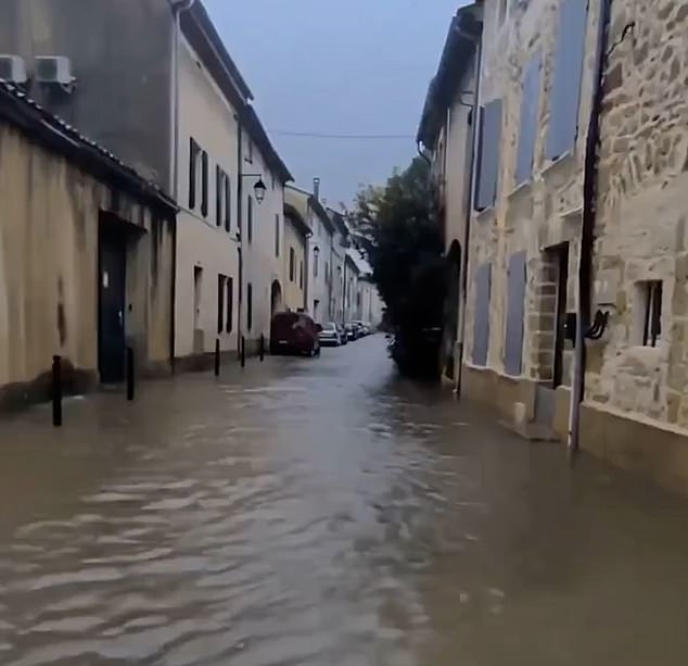
Dramatic video footage has captured the impact of the extreme weather in the picturesque coastal Carmague region of southern France, with the streets flooded with ankle-deep water following heavy rainfall.
An ‘orange alert’ for thunderstorms and vast flooding has also been introduced across both Paris and the Île-de-France region.
In Provence and the Alpes, ‘intense, widespread and thundery’ rainfall could reach as high as up to 70 to 90mm in some areas and, locally, 120mm in just a few hours, forecasters Meteo France warned.
Further south, ‘hail, sometimes medium or large, strong electrical activity, violent gusts and even whirlwinds’ are forecast, with temporary ‘violent gusts of wind’ expected near the coast in particular.
The stormy conditions are understood to be due to a powerful Atlantic high-level current which is crossing France from Brittany.
As a result, ‘numerous thunderstorms’ are expected to continue until Monday morning in Brittany and could produce between 60 and 80mm of rainfall overnight.
Meanwhile, gusts of wind at a speed of up to 50 to 70km/h are anticipated to occur over the Channel.

Dramatic video footage has captured the impact of the extreme weather in the picturesque coastal Carmague region of southern France, with the streets flooded with ankle-deep water following heavy rainfall. A severe weather alert has been issued for swathes of the country
French residents and tourists, many of whom may have been hoping to bask in the final rays of summer sun, have now been advised to remain vigilant and avoid travel where possible due to the storm’s ‘intensity and the expected cumulative rainfall’.
In a post on social media platform X, Mateo France warned: ‘A worsening rainstorm will cross the southeast of the country on Sunday afternoon and evening.
‘Significant accumulations of #rain in a short period of time are to be feared, but also a risk of hail and gusts of wind.’
Across the country, temperatures are expected to range between 12 and 17 degrees across the northeast of the country on September 21, exceeding to between 21 and 26 degrees near the Mediterranean.
In Marseille, Paris Saint-Germain’s highly anticipated Ligue 1 match with Marseille has been postponed by a day due to the severe weather conditions in the Bouches-du-Rhone region.
Announcing the news, a statement released by Marseille, said: ‘Olympique de Marseille acknowledges the decision of the Bouches-du-Rhône Prefecture to postpone the OM – PSG match, initially scheduled for this evening, for security reasons linked to the weather conditions in the region.
‘As communicated by the Professional Football League, and in accordance with its regulations, the match is rescheduled for this Monday, September 22 at 8 p.m., at the Orange Velodrome.
‘The club informs its supporters that tickets purchased for tonight’s match will remain valid for tomorrow’s rescheduled match.

French residents and tourists, many of whom may have been hoping to bask in the last rays of summer sun, have now been advised to remain vigilant and avoid travel where possible due to the storm’s ‘intensity and the expected cumulative rainfall’
‘Olympique de Marseille regrets that the conditions are not right to play the match this evening, both for its players, for its mobilised supporters already present, and for the full visibility of the event.’
It comes just days after ‘biblical’ weather hammered Spain, with violent storms unleashing 100kph winds, flash floods, and chaos across the country.
Dramatic video showed palm trees snapping in half in Alicante and streets in Majorca turning into rivers as the Med braces for ‘hazardous’ thunderstorms and ‘extreme’ flooding.
The Murcia region was badly hit and in the city of Caravaca de la Cruz, a major pilgrimage site, golf-sized hail balls smashed down on cars.
Up to 20 residents from the city were evacuated and spent the night in a municipal sports pavilion, according to local reports.
The hail turned into enormous mounds of ice before quickly melting with rapids forming.
Mucky fast-flowing water streamed through the region, filling some homes and businesses, leaving the roads barren.
Cafes and restaurants were left empty with people taking shelter.
Calasparra and Casas Navarro were among the most affected areas.